Latest News
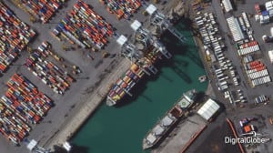
[Via Satellite 02-25-2015] DigitalGlobe announced today it has started selling high resolution, 30 cm imagery from its latest satellite, WorldView 3. At this resolution, rated 5.7 on the National Imagery Interpretability Rating Scale (NIIRS), details such as aboveground utility lines in residential neighborhoods, manhole covers, building vents, fire hydrants, and individual seams on locomotives can be discerned from space.
DigitalGlobe plans to enter head to head competition with aerial imagery providers, who have held a competitive advantage by offering high-resolution imagery taken by aircraft. According to the company, satellite imagery can be delivered in days or weeks, compared to months, and is added to a growing collection of archived imagery.
WorldView 3 can see through smoke, haze, and smog by using shortwave infrared (SWIR) capabilities. SWIR imagery, previously unavailable to commercial customers, can now also be sold. DigitalGlobe began a beta program with partners for SWIR imagery at 7.5 meter resolution, to explore new uses for this capability.
Get the latest Via Satellite news!
Subscribe Now