Latest News
Maxar said the Raptor Guide software can allow an autonomous system to navigate with precision without GPS. Photo: Maxar
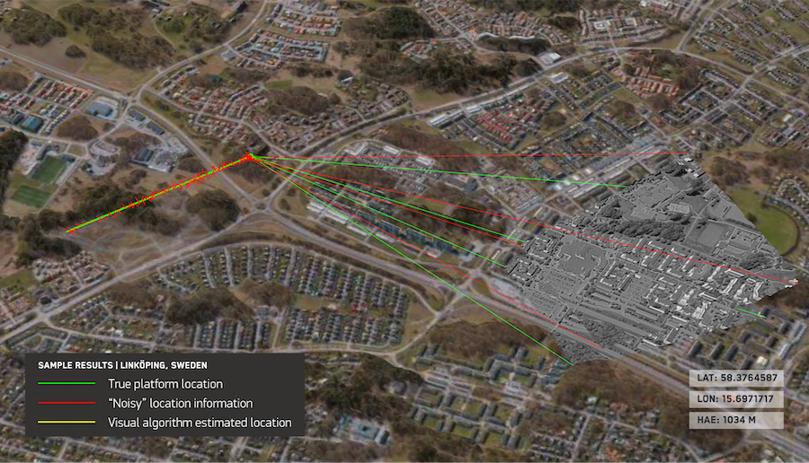
Maxar Intelligence has a new software offering called Raptor that uses the company’s 3D terrain data to allow autonomous drones to navigate environments without GPS.
Maxar announced Raptor on Tuesday, and the company said the software uses only a drone’s native camera and Maxar’s global 3D terrain data to help the platform navigate and extract accurate ground coordinates in real-time without GPS. Maxar has more than 90 million square kilometers of global 3D terrain data, which combines the company’s satellite imagery archive with 3D technology.
Maxar said Raptor can support autonomous systems for surveillance, reconnaissance, and tactical operations, but it is also applicable to autonomous delivery systems for logistics, and search and rescue operations. The company pitched Raptor as a solution for GPS interference.
“By eliminating reliance on GPS, Raptor software unlocks the full potential of autonomous systems—from powering truly joint multi-domain operations as part of a digital battlefield to large-scale delivery systems in urban areas where knowing the precise coordinates of your drop-off location is critical to getting the job done,” said Peter Wilczynski, chief product officer at Maxar Intelligence.
The product suite includes vision-based positioning software for autonomous platforms; software that can georegister a video feed from a drone with Maxar’s 3D terrain data in real time; and software that can work on commodity laptops for drone control. No additional hardware is needed.
Stay connected and get ahead with the leading source of industry intel!
Subscribe Now