Latest News

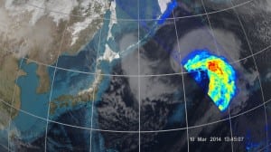
One of the first images from the GPM Core Observatory showing the March 10 cyclone. Photo: NASA/JAXA
[Via Satellite 03-26-2014] NASA and the Japan Aerospace Exploration Agency (JAXA) have released the first images captured by the Global Precipitation Measurement (GPM) Core Observatory, an Earth-observing satellite launched Feb. 27. The images show precipitation from a March 10 cyclone in northwest Pacific Ocean near Japan.
The data was collected with JAXA’s dual-frequency precipitation radar (DPR), which imaged a three-dimensional cross-section of the storm, and NASA’s GPM microwave imager (GMI), which observed precipitation across a broad stretch of spectrum.
“It was really exciting to see this high-quality GPM data for the first time,” said Gail Skofronick-Jackson, GPM project scientist at NASA’s Goddard Spaceflight Center in Greenbelt, Md. “I knew we had entered a new era in measuring precipitation from space. We now can measure global precipitation of all types, from light drizzle to heavy downpours to falling snow.”
The GMI instrument has 13 channels that measure natural energy radiated by Earth’s surface and by precipitation itself. Since liquid raindrops and ice particles affect the microwave energy differently, each channel is designed to be sensitive to a different precipitation type, making the GPM Core Observatory the first spacecraft to detect light rain and snowfall from space. The DPR instrument sends signals that bounce off the raindrops and snowflakes to reveal the 3-D structure of the storm. Like GMI, its two frequencies are sensitive to different rain and snow particle sizes: one frequency senses moderate to heavy rain, and a second radar frequency is used for lighter rainfall and snowfall. Data from the two instruments contribute to more accurate rain estimates, which scientists use to calculate rain rate, one of the device’s essential measurements.
Get the latest Via Satellite news!
Subscribe Now