Government/Military

Harris-NASA Team Receive R&D 100 Award for New Ka-band SDR Technology
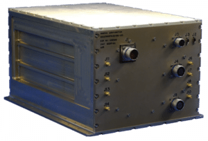
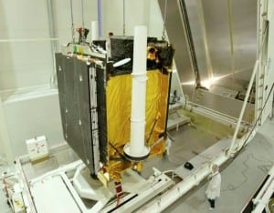
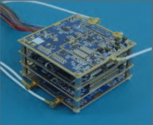
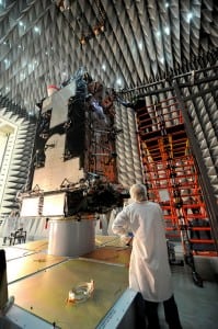
[Via Satellite 11-08-13] The Harris Corporation was honored with an R&D 100 award for developing a reconfigurable space-borne radio as part of a NASA-led team. The awards, presented annually by R&D Magazine, recognize the 100 most technologically significant innovations from across the United States. Space-based remote data collection has accelerated rapidly in recent years, requiring...
Government/Military
Harris NASA AppStar
Soyuz Launched to ISS Carrying Olympic Torch
[Via Satellite 11-07-13] Arianespace has carried out an exciting launch in Kazakhstan carrying the Olympic torch into the space as part its preparations for the Winter Olympics next year, which will take place in Sochi, Russia. The Soyuz launch carrying a crew of three along with the Olympic torch occurred at 8:14 a.m. MSK from...
Finance
Soyuz Launch Olympics Arianespace
UK Ministry of Defense Receives new Terminals from Astrium
[Via Satellite 11-07-13] Astrium will deliver new terminals to the U.K. Ministry of Defense (MOD) and related IP baseband, to enable secure communications on frontlines overseas, Astrium announced Nov. 7. These new deliveries are based on communications via the company’s X-band satellites through the Skynet 5 program, now in its 10th year. The U.K. MOD...
Connectivity
Skynet 5A UK MOD Terminal
US Army Selects Tethers Unlimited for SBIR Contract
[Via Satellite 11-06-13] The U.S. Army’s Space and Missile Defense Command (SMDC) has awarded Tethers Unlimited (TUI) a Phase II Small Business Innovation Research (SBIR) contract to complete development of a system that will enable CubeSats to communicate directly with handheld UHF radios, which are used by used by Army troops. TUI’s “Swift-TacSatcom” system combines...
Government/Military
Tethers Unlimited TUI SBIR Swift
Exelis Delivers GPS Satellite Simulation Software for US Air Force
[Via Satellite 11-05-13] Exelis successfully completed factory acceptance testing for the GPS 3 navigation payload simulator software. Developed by Exelis, the software will simulate the behavior of GPS signals in space, which will be used for testing the U.S. Air Force’s next generation GPS ground station known as the operational control system (OCX). The simulator...
Government/Military
GPS 3 Exelis Lockheed
Exelis Completes GOES R Primary Payload
[Via Satellite 11-04-13] Exelis has completed the primary payload for the future Geostationary Operational Environmental Satellite, GOES R, weather satellite. The Advanced Baseline Imager (ABI), which provides high-resolution imagery of environmental conditions, will be transported in January to Denver where it will be integrated into the R satellite for a scheduled 2016 launch. The ABI...
Government/Military
Exelis ABI GOES R NOAA
EIAST’s DubaiSat 2 moved to Russia
[Via Satellite 11-04-13] The Emirates Institution for Advanced Science and Technology (EIAST) announced that it has moved the DubaiSat 2 satellite from South Korea to Russia. DubaiSat 2 will be launched on a Dnepr Rocket through the Moscow-based International Space Company Kosmotras, from Yasny Launch Base. As part of its initiative to support the UAE’s...
Government/Military
DubaiSat 2 EIAST
Eutelsat 5 West A Satellite Chosen for NGO Communications
[Via Satellite 11-01-13] UltiSat has signed a multi-year contract with Eutelsat for capacity on the satellite Eutelsat 5 West A. Taking advantage of the satellite’s C-band coverage of Africa, it will be used to provide nongovernmental organizations (NGOs) with managed satellite network solutions. “Few organizations find themselves in more remote or hostile environments than nongovernmental...
Connectivity
Ultisat NGO Eutelsat
Astrium and IHS Partner to Support GEOINT Community
[Via Satellite 10-31-13] Astrium has entered into a partnership agreement with IHS to deliver satellite imagery and services for intelligence analysis and reporting. The partnership will enable IHS to meet demand for fused intelligence sources to tap easily accessed information. Invariably, geospatial data plays a critical role in developing intelligence, formulating strategic policy and driving...
Government/Military
geospatial astrium ihs
ViaSat and Green Hills Software Team to Deliver Secure Android Smartphones
[Via Satellite 10-30-13] ViaSat and Green Hills Software have partnered to deliver military-grade security for Android smartphones and tablets. The INTEGRITY Multivisor separation-kernel has been selected as the hypervisor solution for ViaSat Secured, a mobile enterprise system that addresses the stringent security, privacy, manageability, and usability demands for dual-use, personal and business, smartphones and tablets....
Connectivity
ViaSat Green Hill Secure Android Smartphone